Thunderstorms and damaging winds and some snow is expected for parts of the country.
It'll be a cold and wet start to the week for some parts of the country, according to the South African Weather Service, which has issued warnings for severe thunderstorms, damaging winds and snow in various parts of the country.
Impact-based warnings:
A Level 2 warning was issued for damaging winds that could lead to difficulty in navigation at sea between Alexander Bay and Plettenberg Bay.
A similar warning was issued for severe thunderstorms, with damaging winds, heavy downpours and large amounts of small hail over the north-eastern parts of the Northern Cape and south-western parts of the North West.
A third Level 2 warning was issued for snowfall that could lead to pass closures, dangerous driving conditions and a loss of vulnerable livestock over the extreme western parts of KwaZulu-Natal and the extreme eastern parts of the Free State.
Fire danger warning:
Meanwhile, extremely high fire danger conditions are expected over Kamiesberg in the Northern Cape, the Matzikama and Cederberg Local Municipalities of the Western Cape, as well as the Kagisano-Molopo Local Municipality in the North West.
Advisories:
An intense cut-off low-pressure system is expected to affect the southern, central and eastern parts of the country until Wednesday. The public and small-stock farmers have been advised that cold to very cold, wet and windy conditions are expected over the Eastern Cape, KwaZulu-Natal, Free State, Mpumalanga, Gauteng, Limpopo and the North West.
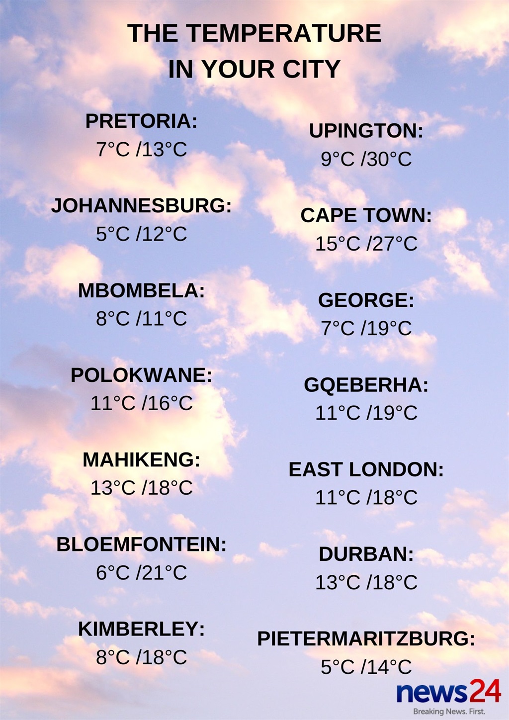
The weather in your province:
Gauteng will be cloudy and cold with scattered showers and thundershowers, but cool in places in the north.
The expected UVB sunburn Index is low.
Morning fog is expected over the highveld of Mpumalanga. It will otherwise be cloudy and cold with scattered showers and thundershowers, but isolated in the lowveld where it will be cool. It will be very cold in places along the escarpment with possible snow in the south.
Limpopo can expect morning fog along the escarpment; otherwise cloudy and cool to cold conditions have been forecast, along with isolated showers and thundershowers, which will be scattered in the east and north.
The North West will be cloudy, windy and cold to cool with scattered showers and thundershowers.
It will be cloudy, windy and cold to very cold in the Free State, with scattered showers and thundershowers. Snowfall is expected over areas near the Drakensberg.
Fine conditions are expected in the western parts of the Northern Cape. It will otherwise be partly cloudy, windy and cool to warm with isolated to scattered showers and thundershowers. It will be hot along the coastal areas with possible dust storms.
The wind along the coast will be fresh to strong south-easterly to easterly.
It will be partly cloudy in the eastern parts of the Western Cape, otherwise fine and cool to warm but hot over the northern parts of the West Coast District.
The wind along the coast will be fresh to strong south-easterly to easterly, but reaching gale force along the south-west coast.
The expected UVB sunburn index is very high.
Partly cloudy, windy and cool conditions expected for the western half of the Eastern Cape. The wind along the coast will be fresh easterly.
The eastern half of the province will be cloudy with isolated showers and thundershowers in the north, otherwise partly cloud, windy and cold conditions are expected with light rain along the coast and in the extreme east.
Snowfalls are possible in the morning in the extreme north-east.
The wind along the coast will be fresh easterly, becoming north-easterly in the afternoon.
KwaZulu-Natal will be cloudy and cold but very cold over the western parts. Isolated showers and rain are expected but scattered in the north-western parts of the province. Snow is expected over the western high ground.
The wind along the coast will be moderate to fresh southerly to south-westerly, becoming south-easterly south of Durban.
The expected UVB sunburn index is high.