Warnings for disruptive rain has been issued for large parts of the Eastern Cape.
The South African Weather Service has issued a number of warnings for disruptive rain that could lead to floods and damage to property in large parts of the Eastern Cape.
Alerts for severe thunderstorms in the parts of KwaZulu-Natal and the Northern Cape and Western Cape have also been issued.
Impacted-based warnings:
A. An Orange Level 6 warning has been issued for disruptive rain that could lead to flooding, danger to life and damage to property over the south-eastern parts of the Eastern Cape.
B. A Yellow Level 2 warning has been issued for disruptive rain with impacts that include flooding, danger to life and damage to property in the Eastern Cape, except in the extreme north-eastern parts of the province.
C. A Yellow Level 2 warning has been issued for severe thunderstorms with damaging winds, large amounts of small hail and heavy downpours that could lead to localised flash flooding over the central and eastern parts of the Western Cape, the southern parts of the Northern Cape as well as the western parts and Midlands of Kwazulu-Natal.
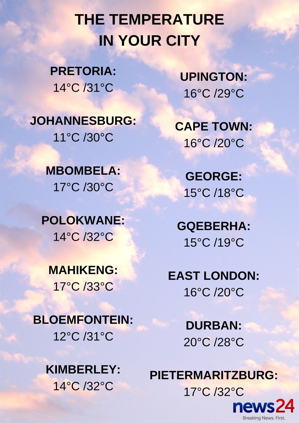
Weather in your province:
Gauteng will be partly cloudy and warm.
The expected UVB sunburn index is extreme.
Fine and hot to very hot weather is forecast for Mpumalanga.
Limpopo will be fine and hot to very hot.
Partly cloudy, windy and hot conditions with isolated showers and thundershowers are expected in the North West, except over the western parts of the province.
The Free State can expect partly cloudy, windy and warm to hot conditions with isolated showers and thundershowers but scattered over the southern parts of the province.
It will be cloudy with morning fog patches over the southern parts of the Northern Cape at first, otherwise partly cloudy, windy, and cool to warm weather with isolated to scattered showers and thundershowers expected, except over the central and northern parts.
The wind along the coast will be light to moderate north-westerly, becoming southerly to south-easterly in the afternoon.
Cloudy and cool to warm weather is expected in the Western Cape, with isolated to scattered showers and thundershowers which will be widespread in the south-east.
The wind along the coast will be fresh to strong south-easterly reaching gale force between Cape Columbine and Robben Island late morning until mid-afternoon.
The expected UVB sunburn index is high.
It will be cloudy and cool with widespread showers and thundershowers in the western half of the Eastern Cape.
The wind along the coast will be moderate to fresh south-easterly.
The eastern half of the province can expect cloudy and cool conditions with widespread showers and thundershowers but scattered in the extreme north.
The wind along the coast will be moderate to fresh south-easterly, but moderate to fresh southerly along the Wild Coast.
Large parts of KwaZulu-Natal can expect partly cloudy and warm conditions, but it will be hot in places in the north.
It will become cloudy with isolated to scattered showers and thundershowers but widespread in the extreme south.
The wind along the coast will be moderate to fresh north-easterly north of Durban, otherwise light to moderate southerly to south-westerly, becoming fresh at times.
The expected UVB sunburn index is high.