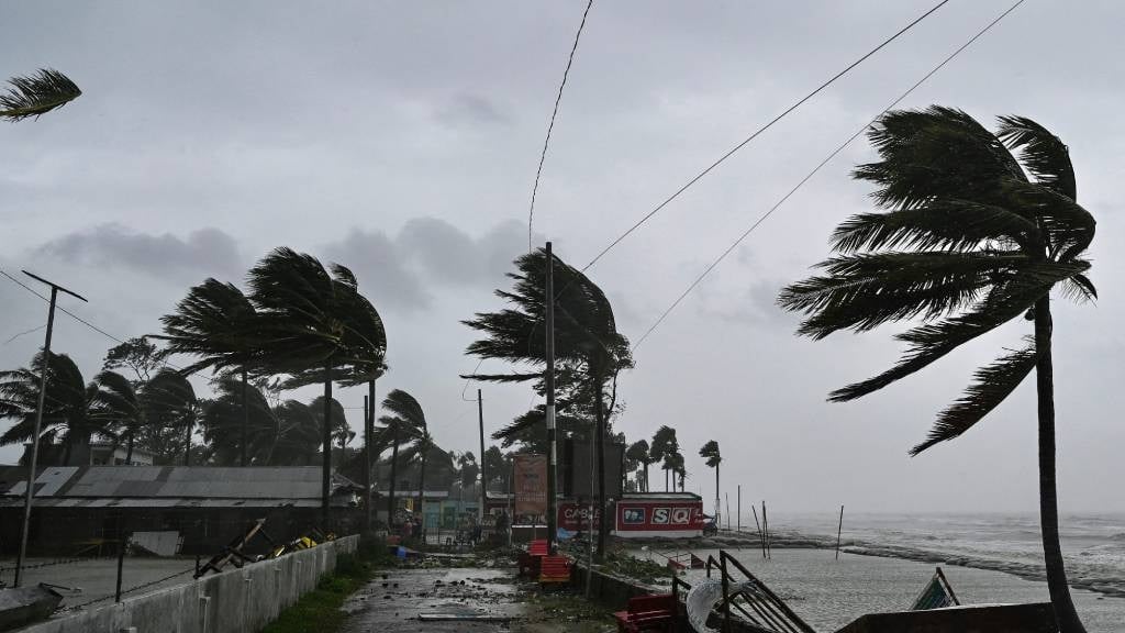
Multiple warnings have been issued for damaging waves and wind. (Munir Uz Zaman/AFP)
The South African Weather Service issued several warnings for damaging wind and waves, as well as a high risk of fires, for several regions across the country.
Impact-based warnings
A Yellow Level 1 warning for damaging winds, leading to difficulty in navigation at sea, is expected between Cape Columbine and Cape Agulhas.
A Yellow Level 3 warning for damaging waves, leading to disruption of small harbours and ports, between Alexander Bay and Plettenberg Bay in the evening.
A Yellow Level 1 warning for damaging interior winds, leading to localised problems for high-sided vehicles on prone routes, is expected over the southern parts of the Pixley Ka Seme and Namakwa District Municipalities in the Northern Cape as well as the Central Karoo District Municipality in the Western Cape.
A Yellow Level 2 warning for damaging winds, resulting in localised damage to settlements and temporary structures, as well as dangerous driving conditions, is expected over the Chris Hani and Joe Gqabi District Municipalities as well as Amahlathi and Matatiele Local Municipalities in the Eastern Cape.
Fire danger warnings
Extremely high fire danger conditions are expected in places over the central parts of the country, the western parts of KwaZulu-Natal as well as in places over the Central and Little Karoo District Municipalities in the Western Cape.
Advisories
A cold front is expected to pass through the Eastern Cape on Wednesday.
The public and small stock farmers can expect cold conditions, strong to gale force winds along the coast and over the interior, as well as high seas.
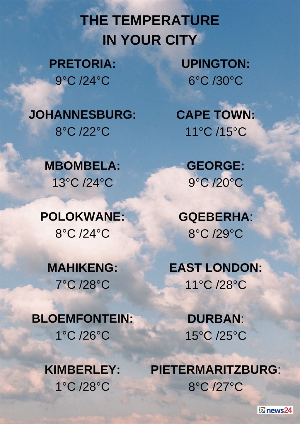
The weather in your region
Gauteng will be fine and cool, but warm in the north.
The expected UVB sunburn index is high.
Morning fog patches are expected in Mpumalanga over the central and eastern Highveld, otherwise it will be fine and cool to warm.
It will be partly cloudy in the east.
Limpopo can expect cloudy conditions in the east in the morning, otherwise it will be partly cloudy and warm, with morning fog patches over the central parts, becoming fine from the afternoon.
It will be cool over the central parts.
Fine, windy and warm temperatures are forecast in the North West.
The Free State will be fine, windy and cool to warm.
Cloudy conditions, with morning fog patches along the coast, are expected in the Northern Cape.
It will be partly cloudy and cool to cold, but fine and warm in the east.
Windy conditions are expected over the southern parts.
The wind along the coast will be a moderate to fresh south-easterly to southerly, becoming a moderate to fresh north-westerly from the afternoon.
The Western Cape can expect cloudy conditions and cold to cool temperatures, but it will be warm over the Central Karoo and northern Garden Route areas, with isolated to scattered rain over the western parts from the afternoon.
The wind along the coast will be a fresh to strong north-westerly to westerly along the south-western and southern coast, but gale from the afternoon, becoming a fresh south-westerly along the western and south-western coast from the evening.
The expected UVB sunburn index is low.
Partly cloudy and cool conditions are forecast in places over the western half of the Eastern Cape.
It will be fine, windy and warm, but cloudy, with isolated showers and rain, along the coast west of Gqeberha at night.
The wind along the coast will be a moderate to fresh north-westerly, becoming a fresh to strong south-westerly wind in the afternoon, reaching gale force west of Gqeberha at night.
The eastern half of the province will be cool in the north.
It will be fine, windy and warm, but partly cloudy in places.
The wind along the coast will be a light to moderate north-westerly in places, otherwise a moderate to fresh north-easterly is forecast.
It will become a fresh to strong south-westerly from the south in the evening.
KwaZulu-Natal will have morning fog patches, otherwise it will be partly cloudy and warm.
The wind along the coast will be a moderate to fresh northerly to north-easterly, but strong at times in the north.
The expected UVB sunburn index is very high.