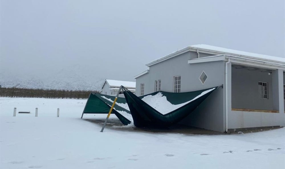
Disruptive snow, rain and winds are expected in several regions, while a high risk of fires is forecast in at least three provinces. (Derick van Zyl/Supplied)
Multiple warnings for disruptive snow, wind and heavy rainfall have been issued by the South African Weather Service, but extremely high fire danger conditions are forecast in at least three provinces.
Impact-based warnings
A Yellow Level 4 warning for damaging winds has been issued along the coast between Lambert's Bay and Mossel Bay.
A Yellow Level 2 warning for damaging winds and waves has been issued between Table and Cape Agulhas.
A Yellow Level 4 warning has been issued for disruptive rain leading to flooding of roads and settlements in the City of Cape Town, Swartland, Bergrivier, Cederberg, Drakenstein, Witzenberg, Theewaterskloof and Stellenbosch local municipalities of the Western Cape.
An Orange Level 6 warning for disruptive rainfall leading to flooding of roads and settlements has been issued over the southern parts of Witzenberg, Drakenstein and Stellenbosch local municipalities in the Western Cape.
A Yellow Level 2 warning has been issued for damaging winds resulting in damage to property, and communication and power interruptions can be expected in places over Enoch Mgijima, Emalahleni, Sakhisizwe, Senqu and Elundini local municipalities in the Eastern Cape, as well as Xhariep District Municipality in the Free State.
A Yellow Level 2 warning for disruptive snow has been issued over the mountainous regions of the Witzenberg Local Municipality in the Western Cape and Karoo Hoogland Local Municipality in the Northern Cape.
Fire danger warnings
Extremely high fire danger conditions are expected over the eastern parts of the Northern Cape, in places over the North West, and the western parts of the Free State, as well as in places over Joe Gqabi and Chris Hani District Municipalities in the Eastern Cape.
Advisories
A series of cold fronts are expected to affect the Western and Northern Cape until Sunday. The public and small stock farmers are advised that intermittent heavy rainfall, snowfalls, very cold conditions, strong coastal and interior winds, and very rough seas can be expected.
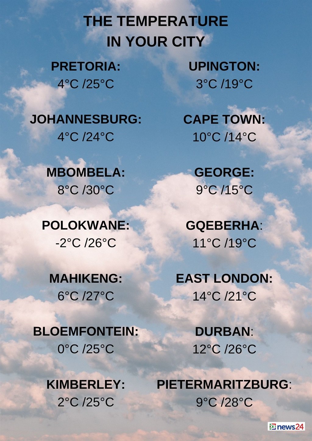
The weather in your region
Gauteng will be fine and cool to warm.
The expected UVB sunburn index is very high.
Fine and warm temperatures are forecast in Mpumalanga and Limpopo, but it will be hot in places in the Lowveld and Limpopo Valley.
The North West and Limpopo can expect fine, windy and cool to warm conditions.
Cloudy conditions are expected in the west of the Northern Cape, with isolated showers and rain in the south-west.
Otherwise, it will be partly cloudy, windy and cold to cool, but very cold over the southern parts. It will be fine in the north-east.
The wind along the coast will be a moderate to fresh westerly to north-westerly, but strong at times in the morning.
The Western Cape will be cloudy and cold with isolated showers and rain in the west, but scattered to widespread over the south-western parts.
Possible thundershowers are expected over the south-western parts from the afternoon.
The wind along the coast will be a moderate to fresh northerly to north-westerly, but strong along the south-west coast.
The expected UVB sunburn index is low.
New development behind the cold front of this morning, Western Cape can expect more rain tomorrow with strong winds and waves along the coastline again. pic.twitter.com/CyNwdSYISk
— SA Weather Service (@SAWeatherServic) July 12, 2024Fine and cool conditions are forecast in the western half of the Eastern Cape, becoming partly cloudy in the afternoon, but it will be cloudy in the evening with light rain and isolated showers along the coast and adjacent interior
The wind along the coast will be light and variable.
Fine and cool to warm temperatures are expected in the eastern half of the province.
The wind along the coast will be light and variable, but a moderate westerly wind is expected at times in places.
KwaZulu-Natal can expect fine and warm conditions.
The wind along the coast will be a light to moderate southerly to south-westerly south of Richards Bay until late afternoon.
Otherwise, a moderate to fresh northerly to north-easterly wind is expected.
The expected UVB sunburn index is high.