Autumn's here with partly cloudy and cloudy conditions for most provinces in the country. (Oliver Strewe/Getty Images)
The South African Weather Service has welcomed the start of autumn with a forecast of cloudy and partly cloudy conditions for most parts of the country.
Impact-based warnings
A Yellow Level 2 warning for damaging winds leading to small vessels and personal watercraft being at risk of taking on water and capsizing has been issued between Cape Agulhas and Cape Columbine from late afternoon into Sunday.
Advisory
A heatwave with persistently high temperatures is expected over Dr Beyers Naude and Inxuba Yethemba local municipalities of the Eastern Cape.
The Autumn season has started??. Do you know what weather conditions are associated with the Autumn season in South Africa??? pic.twitter.com/vHlDVYzyKu
— SA Weather Service (@SAWeatherServic) March 1, 2024The weather in your region
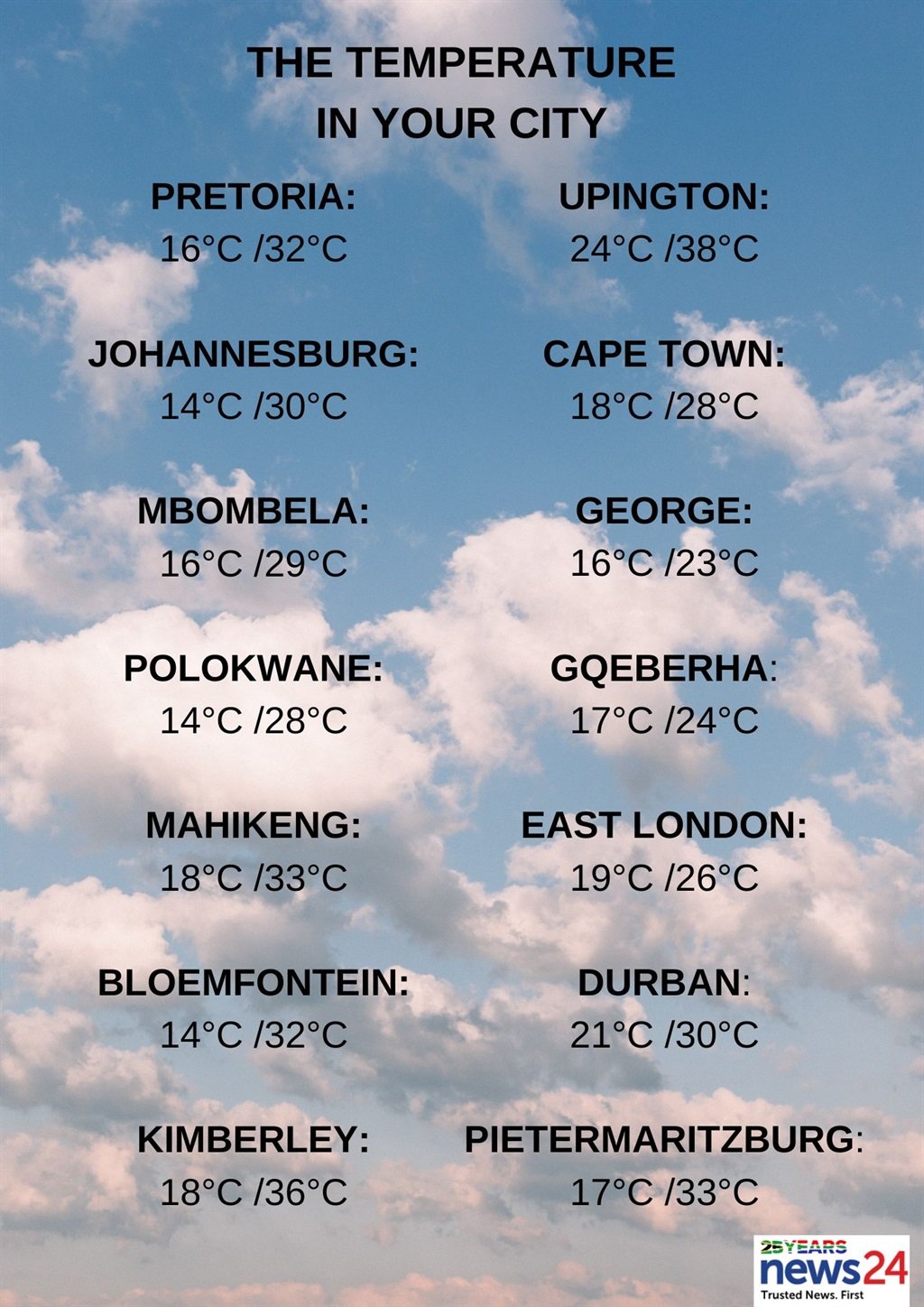
Gauteng will be fine with warm to hot temperatures, becoming partly cloudy in the afternoon.
The expected UVB sunburn index is very high.
Partly cloudy conditions are expected in Mpumalanga over the eastern parts in the morning, with fog patches on the southern and eastern Highveld.
Otherwise, fine and warm to hot temperatures are forecast for the Lowveld.
Limpopo is expected to be cloudy along the escarpment in the morning. Otherwise, partly cloudy and warm to hot but fine conditions are expected over the southern and western parts.
Partly cloudy and warm to hot temperatures are expected in the North West, with isolated showers and thundershowers in the extreme north-east.
The Free State will be partly cloudy and warm to hot, with isolated showers and thundershowers, except in the extreme north-east.
Cloudy conditions with fog along the coast are forecast for the Northern Cape and the adjacent interior in the morning where it will be cool in places.
Otherwise, fine and warm to hot temperatures are expected, but partly cloudy conditions are forecast over the east and north-western parts where it will be very hot in places.
Isolated thundershowers are expected over the north-eastern parts.
The wind along the coast will be a light to moderate southerly to south-easterly, becoming fresh to strong from the afternoon.
The Western Cape will be partly cloudy along the coast, but cloudy along the west and south coast where fog patches are possible in the morning.
It will become fine in the north-west from the afternoon. Isolated showers and rain are expected over the western parts of the south coast from the afternoon.
The wind along the coast will be a moderate to fresh southerly to south-easterly, but westerly to north-westerly along the south coast in the morning.
It will become strong to near gale force along the south-west coast from the afternoon.
The expected UVB sunburn index is very high.
It will be cloudy along the coast at times over the western half of the Eastern Cape.
Otherwise, fine and warm to hot but very hot temperatures are forecast in places over the interior.
It will become partly cloudy in the north in the afternoon with isolated showers and thundershowers in the north-east.
Light rain is expected in places along the coast in the evening.
The wind along the coast will be a moderate south-westerly, becoming light and variable west of Gqeberha from late afternoon.
The eastern half of the province will be cloudy along the coast at times.
Otherwise, fine and warm to hot conditions are expected, becoming partly cloudy with isolated showers and thundershowers in the afternoon.
The wind along the coast will be a moderate south-westerly.
KwaZulu-Natal will have morning fog patches over the interior. Otherwise, fine and warm but hot temperatures are forecast in the north.
It will become partly cloudy in the south with isolated afternoon thundershowers in the south-west.
The wind along the coast will be a moderate to fresh north-easterly.
The expected UVB sunburn index is very high.

 (1).png)
 10 months ago
21


